


Pt 8B Driving the Historic Route 88
Ascend elevations of 2, 719 feet, then plunge 1, 500 feet in knuckle hairpin turns and switchbacks on the historic Apache trail (Pt2) to Rosevelt Dam
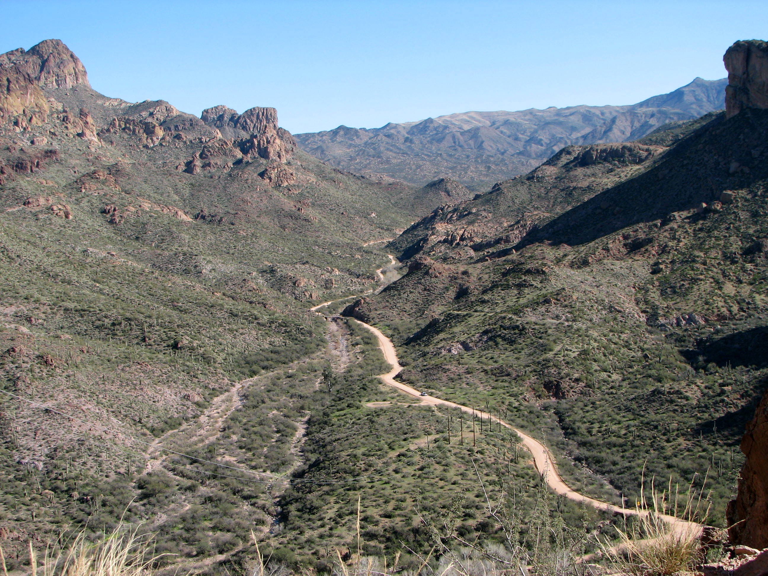
Last week we left Tortilla Flat in our review mirror and journeyed along the Apache towards Roosevelt Dam. This is one of Arizona’s most scenic drives filled with switchbacks and sharp turns with an elevation gain of 2, 719 feet. After fueling up our bellies with some good food and taking advantage of flushable toilets at the Marian we were off to adventure the rest of the historic Apache trail.
Need to catch up?
Depending on how you go,
if you stay on the Apache Trail and do not hit the Marina you will pass a good photo opportunity with the iconic National Forest sign this one bearing “Tonto National Forest Marina and Resort .” This is also a great place to read the plaques filled with the fascinating geological story of the Tonto National Forrest. And soak in the contrast of the marine blue lake and the surrounding purplish vistas and mountains dotted with saguaro cacti. Then after the Marina exit the next pullout is the Apache Lake View Point for what else? Taking in more breathtaking views of the sun-kissed waters and majestic canyons and geological formations.
Once back on the road, you will find a cut off for the Luke Waterdog Recreational site. A great place to launch your boat and get close up views of the surrounding area. A little ways away, you will pass Burnt Corral Recreation Site and Campground along the shoreline.
Nestled among the saguaros, mesquites, and palo verdes, this camp offers a peaceful camping area along the shore of Apache Lake with beautiful views of the lake and the surrounding mountains, especially stunning at sunrise and sunset. This is tent camping at its best. The campground has 77 camp units, vault toilets, potable water hydrants, 6, day-use picnic units, a paved boat launch, and a boat boarding dock. The campsites are shaded by mature mesquite and palo verde trees, and desert chaparral, providing a serene setting. Each campsite comes with fire ring, grill, and picnic tables. This camp is a first come, frist serve for even numbered sites ( I do not know why). Reservations are needed for odd numbered sites on Recreation.gov or by calling 877-444-6777. But who’s balking when its $20/site/night for individual camp unit and $40/site/night for a double camp unit. There are no hookups or dump. Like the rest of the National forest camping, it is a 14-day limit. The campsite can handle any RV under 22 feet. It’s another great loo stop for there are composting and Vault toilets.
I could just imagine camping here, witnessing the most stunning Sonoran Desert landscape, feeling the sunshine upon your face, and cooling off in the clear blue water. There is nothing finer than being privy to the picturesque saguaros surrounded by the Four Peaks and Superstition Wilderness. This is another quiet spot for motor boating, fishing, water-skiing, paddlesports, and hiking. Or, just take in a good book and relax a while, perhaps swaying yourself to sleep in a hammock. Can’t you feel just how good life can be?
About a mile or two is Three Mile Wash Shoreline Area which is temporarily closed until June 2027. It gets its name for being 3 miles south of Roosevelt Dam (pretty original, am I right?). This is a unique space offering shoreline dispersed camping and you might find some larger RV’s as it can handle vehicles up to 40 feet, but not recommended for trailers over 22 feet (and coming in from hwy 188). Bring your fishing and water activities including your paddle board. Tonto Basin Ranger District (602) 225-5395
Now get out the bathing suit, because we have hit Chunk beach after a good switchback. If you're looking to dip your toes in the water, this is the place to do so. This serene and picturesque location is part of the Roosevelt Lake recreation area, making it a popular destination for outdoor enthusiasts seeking a peaceful retreat amidst the stunning desert landscape. Swim among the lush greenery, surrounded by incredible views of the saguaro-studded mountains is worth the drive.
Depending on the water table there is a either a little chunk of beach or a lot. Perhaps this is how it got its name, I can not be certain. I could not find any information as to why it was called this. Also, just to let you know, an Arizona beach is not sand rather small pebbles, so grab those water shoes too. What is wonderful about the salt river is how clean the water is, so don’t be shy to dip a toe or two.
Feeling refreshed by the cool waters, we have just under 3 miles left to reach Roosevelt Dam. The drive becomes less treacherous, finally allowing me to put my heart back in my chest and release my death grip on the door handle (as if that would somehow save my life). I mean, there are parts where, if you look down, you can actually see the remains of cars that didn’t make it. So yeah, I have valid reasons for freaking out.
The road climbs gradually, once again offering spectacular sweeping vistas of the surrounding landscape, including distant mountain ranges and the vast expanse of Roosevelt Lake. The largest lake entirely within Arizona, Roosevelt Lake is a popular destination for water-based recreation. The lake’s crystal clear blue waters are framed by rugged desert hills, creating a stunning setting. The lake is always full of happy campers, swimmers, and boaters pretty much all year round.
And just as you break away from the hypnotic views of the blue reservoir, you see it. Just a glimpse. And a bit of excitement swells as you descend towards the dam. The landscape opens up to reveal the vast expanse of Roosevelt Lake, framed by the majestic Vineyard mountain, Henderson Mesa, Bull Mountain and the Cactus Butte, to jus name a few. As you finally reach your destination, you know you have done so when your tires experience the familiarity of an old paved road

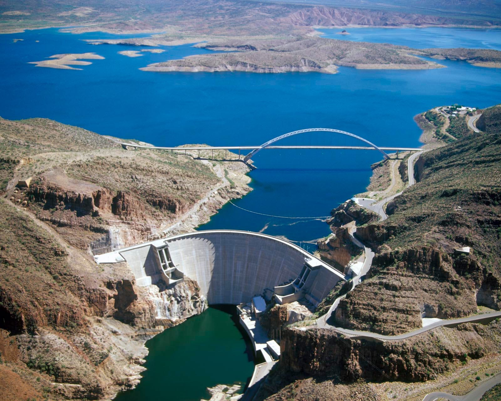
Witnessing the 357-foot high Historic Theodore Roosevelt Dam in the Alchesay Canyon after navigating the Apache Trail is an awe-inspiring experience that once again fuels your sense of adventure after miles of desert. It is not as big as the Hoover Dam, but it is still damn impressive (I couldn't resist). Standing at the overlook, you can feel the cool breeze coming off the lake, and the sun casts a golden glow over the water and the rocky outcrops. The sheer size of the dam, combined with its historical significance, leaves a lasting impression. In fact, Roosevelt remains the largest and most visible of four dams maintained by the Salt River Project (SRP), established in 1909. The dam's massive stone face is a testament to early 20th-century engineering, built with over 344,000 cubic yards of masonry materials holding back over 1.6 million acre-feet of water at Roosevelt Lake.
The 1911-constructed dam was originally called "Salt River Dam Number 1”—pretty boring—and, at the time the world’s largest masonry dam. In 1959 it was renamed after President Theodore Roosevelt, who was a strong advocate for the project. Its construction marked the beginning of large-scale water management projects in the American West. The dam was modeled after the Indigenous Hohokam gravity-based irrigation system, which proved sustainable for more than a thousand years.
The dam was instrumental in transforming the Salt River Valley into a fertile agricultural region, paving the way for the growth of Phoenix and surrounding communities. Initially constructed as a masonry dam, it was later modified in the 1990s to improve its safety and increase its height.
There is a visitor center where you can learn about its history and construction through exhibits and informative displays. It's a great place to understand the significance of the dam and its impact on the Arizona region. On your way up to the massive bridge, stop at the scenic overlook offering a spectacular panoramic perspective of Roosevelt Lake and the surrounding mountains. The clear blue waters of the lake contrast beautifully with the rugged desert terrain and the iconic towering saguaros.
There are several picnic areas around the dam where you can relax and enjoy a meal (or maybe leftovers from the marina) while taking in the stunning views. These spots are equipped with tables and grills, making them perfect for a family outing.
Before heading out along the modern highways, be sure to visit all the surrounding areas. Start with Inspiration Point Interpretive Overlook for a breathtaking view of the dam from the other side.
Next, explore Government Hill, the primary construction camp for workers building the Roosevelt Dam. Here, you can find historical markers and informational plaques that provide insight into the lives of the workers and the construction of the dam. This site also offers more stunning panoramic views of the dam, the lake, and the surrounding mountains, Salt River, and Tonto Creek. Finish up with the Roosevelt Lake Visitors Center. The rear patio has spectacular views of the lake. Inside are exhibits, videos and information on activities and attractions around the lake.
No trip is complete without driving over the Roosevelt Lake Bridge. Did you know before this bridge was built, traffic drove over the top of the dam up until 1990s? The $21.3 million bridge was built to take traffic (and the stress) off the top of Roosevelt Dam.
The bridge is a popular spot for photographers due to its unique design and the stunning backdrop. It is the longest two-lane, single-span, steel-arch bridge in North America, spanning 1,080 feet across Roosevelt Lake providing two-way traffic. Sunset and sunrise are particularly beautiful times to capture the bridge and its surroundings.
As you stand on the Roosevelt Lake Bridge, you might find yourself reflecting on your own journey. This bridge represents a crossing—a significant point that connects the past with the present, history with modernity. It guides travelers safely across the expansive lake, offering both beauty and utility. The sense of achievement and wonder at the engineering feat is palpable, making it a fitting end to an adventurous journey along one of Arizona’s most historical scenic routes.
Now I hope you understand why I had to share this magical journey along the historic Apache Trail, a route originally used by Indigenous people long before it was carved out in the early 1900s to support the construction of the Roosevelt Dam. Once traversed by stagecoaches and pioneers, today it invites modern adventurers to explore its breathtaking vistas of rugged desert landscapes and serene blue waters, experiencing the thrill of winding roads—all without a phone signal. This journey juxtaposes the past and present, blending nature's grandeur with historical significance. It leaves you inspired and in awe of Arizona’s hidden treasures, inviting you to explore and reflect on this unforgettable expedition.
I wish I could share with you all the places I have experienced in Arizona; it would take a year to do so. After all, this is not just an Arizona adventure—this is an adventure of truly experiencing the USA as a tourist and sometimes as a local, uncovering secrets, wonders, off-the-beaten-path journeys, and sometimes tourist traps, because it is all worth it. Well, as much as I would like to say I am off to new lands, in order to go East, there is more of Arizona before getting out. I have that and much more for next week. Be sure to subscribe so that you get the next installment next Wednesday right in your in box, just waiting you to grab a cuppa and cozy spot.

If you are enjoying my work and want to keep the creative engines running, consider buying me a coffee (well, I actually drink tea) or, a couple of gallons of diesel? After all, even creativity needs a bit of a fuel boost now and then! ☕️🚍 Whether it’s a tea to spark new ideas or diesel to power through the tough spots, your support means the world to me. Thanks for keeping me inspired and on the move!"
Thank you for reading
~Karen
Thank you Colin for the restack 🙏