


Pt 43 Views, Vistas, and the Long Way to Something Beautiful
Road trip! Where altitude meets attitude and every winding mile invites wonder, reflection, and the joy of taking the scenic route.
It started with snacks, packed gear, and a ridiculous sense of optimism. We weren’t just taking a road trip no. We were chasing elevation, silence, and maybe a little mischief. Our destination? A log-cabin visitor center perched at 7,500 feet, towering limestone cliffs, hidden lakes, and forests so thick they swallow sound. We are journeying through Arizona’s wild high country.
What began as a simple escape from Payson turned into one of the most soul-filling, pine-scented, camera-snapping, perspective-altering days we’ve had in a while.
Need to catch up?
PT 40 Where the Pine Bark Smells Like Butterscotch: Only in Payson, Arizona
Or, Start from the beginning

Snacks prepped—check, gear packed—check, another adventure awaits —check, and we can’t wait.
We decided to book an Airbnb in Pinetop-Lakeside so we could explore the Mogollon Rim properly. We wanted to soak in the surrounding high country, and maybe even wander into Show Low without needing to make the long trek back to Payson. I know, genius and perhaps a bit ambitious for one day. The drive was just under two hours, making it the perfect basecamp for our next round of Rim adventures.
We pulled out of Payson under a morning sun already flexing at 70°F by 7 a.m., with a forecast brushing into the 90s by midafternoon. August here is a peculiar blend. The high country version of summer brings warm days hovering in the mid-80s to low-90s, but with the sweet mercy of overnight lows in the 60s. It’s the kind of breathable heat that still lets you function without sweating through your soul. Unlike the South Valley where even your sunscreen sweats off and the soles of your shoes threaten to fuse to the asphalt.
With Marteen’s custom road-trip playlist queued up, we were rolling. There’s something special about road-tripping with your adult kids. If yours are grown, you’ll get it. There’s a rhythm that settles in. The silence isn’t uncomfortable, and the conversations go deeper. You know what I mean?
But we have to have the art of listening. Somewhere between tracks, they start opening up about their lives, their dreams, their disappointments. Their hopes. They talk about what they want, what they’re afraid of, what they think about love, careers, friendships, the future.
You get a glimpse into who they’ve become. Not just your kid, but this whole, complex, evolving human being with opinions, ideas, and stories you hadn’t yet heard. It's like the road softens everything. And suddenly, you're not just a parent anymore, you're a witness. A passenger on their unfolding path. And honestly? It’s one of the most beautiful things about these kinds of trips. You come for the views, but you end up treasuring the words shared in between.
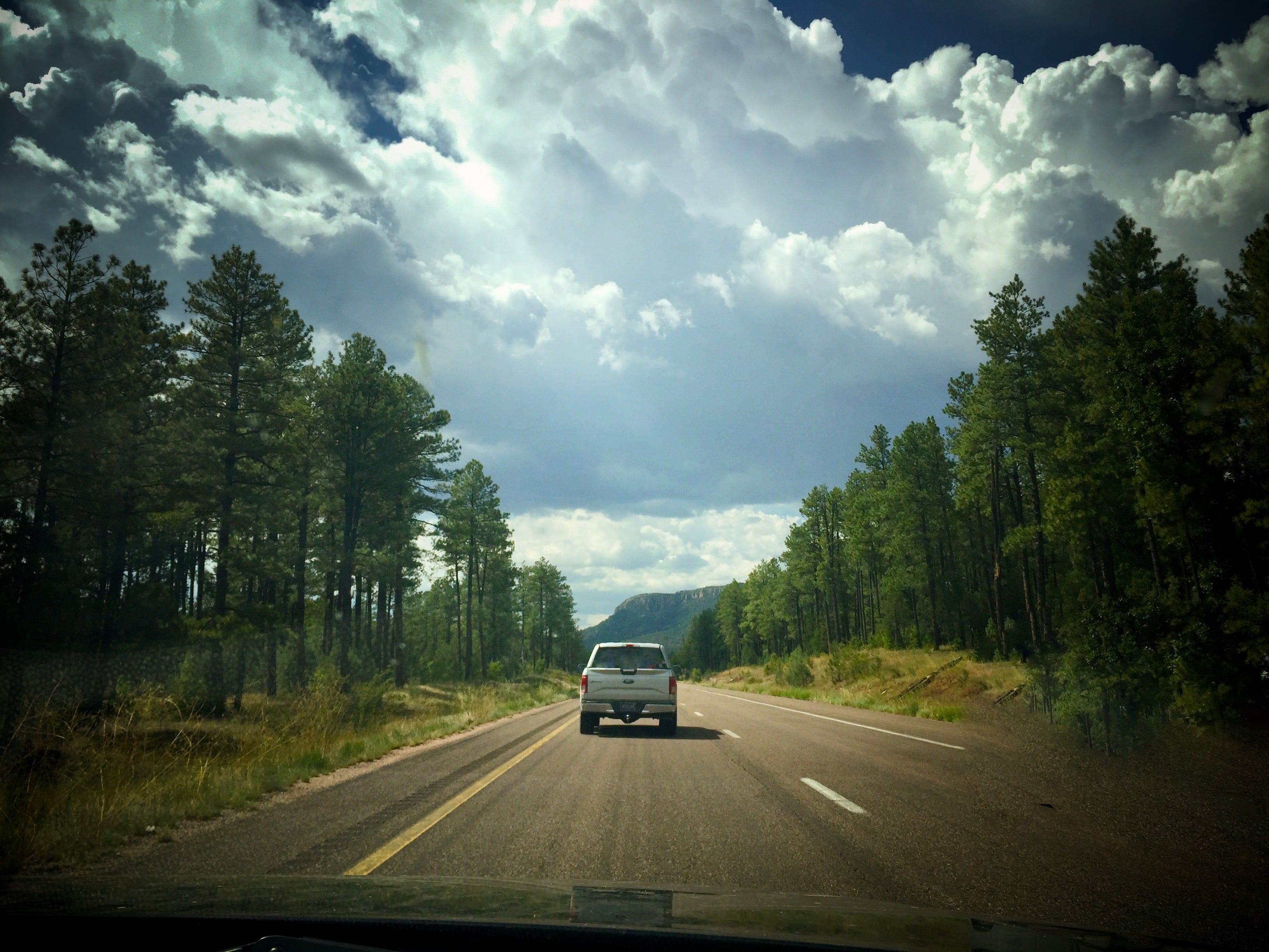
The road from Payson rolls and twists its way into towering pine forests along AZ-260 E, where the desert-pine landscape begins to shift almost immediately into something dreamier, moodier—thicker. At first, the heat still clung to the car like a stubborn layer, but as we began to climb and snake through the terrain, the air cooled, and the scenery opened into something altogether more majestic.
The road curled through dense stands of Ponderosa pine, juniper, and Gambel oak, their branches casting flickering shadows across the windshield like nature’s version of Morse code “come play.” We passed the Wagon Wheel turnoff from the day before and offered it a respectful salute, a nod to the past as we pressed forward, climbing steadily into this high-country realm.
We cruised past narrow pull-outs and dirt roads that vanished into the forest like whispered secrets. I’ve always wanted to take one of those roads on a whim just turn the wheel and follow wherever it leads. I love that kind of serendipitous adventure. My son can tell you about a couple of “Karen adventures” from years ago, coming back from California to Phoenix while his sisters slept soundly in the backseat. Let’s just say, not all backroads lead to scenic lookouts. Some lead to cow pastures, Mexican boarders and questionable gas station bathrooms. But they always make for a story, just not today.
Today, we were on a mission. Still, my thoughts wandered trying to picture the early pioneers rattling their way up these same hills. Wagon wheels creaking, canvas tops flapping like sails in the wind, horses snorting in protest as they pulled their weight against the climb. The road today may be paved, but the spirit of effort is still etched into the hills.
As we gained in elevation and watched through the side mirrors Payson shrank behind us, swallowed by a sea of green. The Mogollon Rim loomed ahead like a fortress wall, massive, ancient, layered with time. The trees grew taller, thicker, more solemn somehow. It seemed as if they were holding the sky aloft on behalf of the Rim. At one bend in the road, the forest parted just enough to reveal a distant mesa, the landscape unfolding like a postcard you didn’t know you were waiting for. Before we knew it we had a first curious stop.
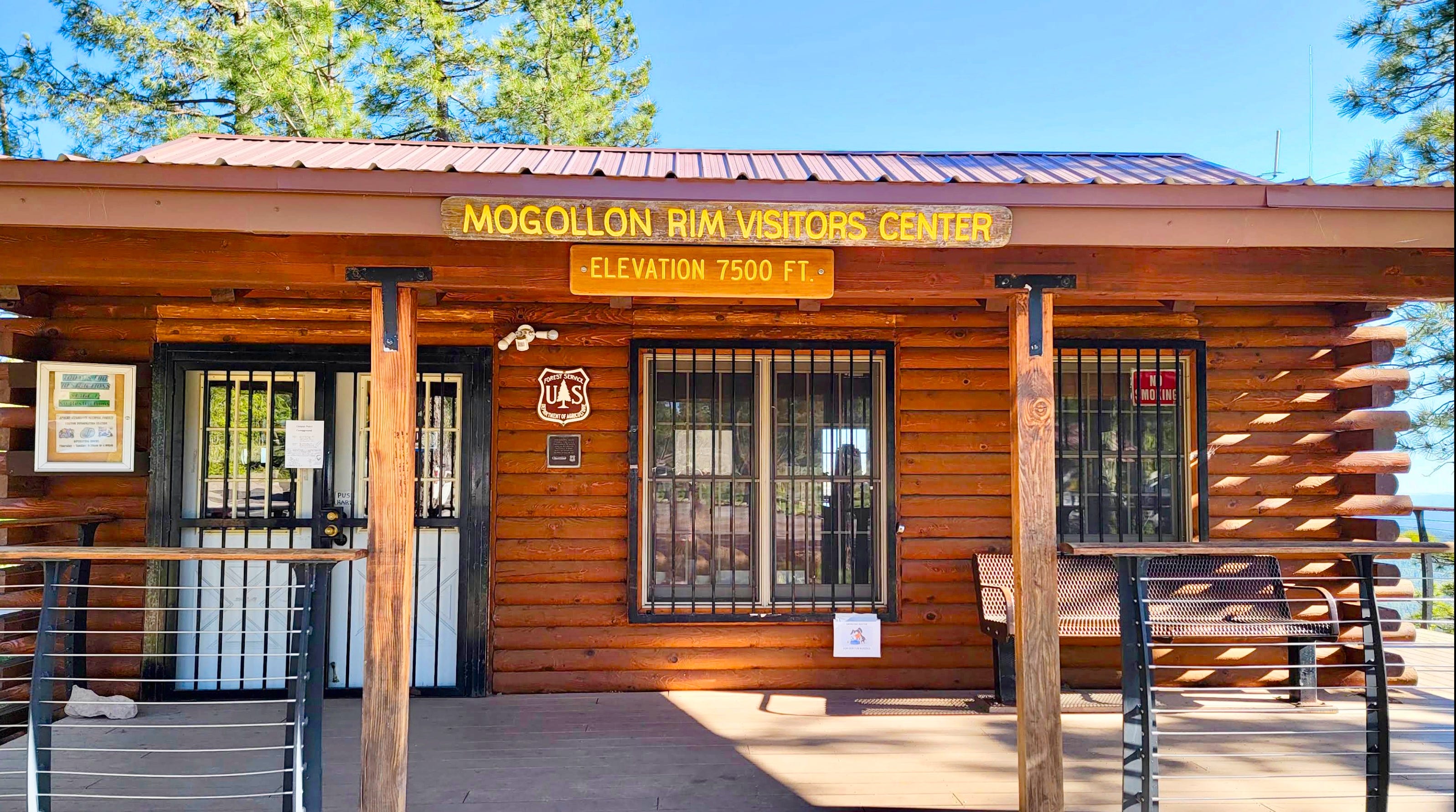
The Mogollon Rim Visitor Center appeared like a quiet invitation to step out, stretch your legs, and step into a whole new world. The air hit us first: cooler, lighter, tinged with pine and something faintly earthy, like sun-warmed bark and stone dust. We were more than happy to breathe in that high country air. And then set our priorities on relieving ourselves of certain biological burdens.
Stepping out of the car was like walking through a portal. The temperature had dropped at least ten degrees, maybe more. The air was crisp and clean, the kind that clears your head. It was quiet. The kind of quiet that amplifies everything natural. A soft breeze whispered through the tall pines, their needles rustling like wind chimes strung by nature itself. It wasn’t just peaceful. It was reverent.
Did you know that this visitor center sits at an elevation of 7,500 feet? I didn’t either. I spotted that little tidbit proudly displayed above the entrance like a Girl Guides hard earned skills badge. Parts of the Mogollon Rim climb even higher, reaching up to 8,000 feet. For perspective, Flagstaff tops out at 6,909 feet, and the base of Arizona Snowbowl starts at 9,200 feet above sea level. So yes, up here, your lungs take notice. It’s not that it’s harder to breathe exactly, but you feel the pause between each inhale as if the air is thinner, closer to the sky.
We were the only ones there. And that felt like a gift. A moment in time suspended just for us. The wind was gentle, carrying the soft sound of whispering pine needles and the occasional birdcall. There’s a stillness at this height that you don’t find in the lower forests. Less buzz of insects, more breeze, a quieter quiet. The kind that makes you instinctively lower your voice, like stepping into a sacred space carved by time and wind.
No campers. No bathroom-breakers. Just us. And I silently thanked Mother Nature for the small ceremony of solitude she was offering.
The visitor center is exactly what you’d hope for at the edge of such a magnificent natural boundary: a quaint, log-cabin-style building with a golden-reddish wood exterior, surrounded by towering pines and perched on the lip of something vast. It doesn’t just sit on the land it seems to belongs to it, as if it grew out of the forest floor like a pine treehouse. Tucked into the greenery, with scenic overlooks wrapping around its sides and interpretive signs sprinkled throughout, it quietly invites you to linger.
There’s just something magical about that all-wood design that strikes a nostalgic chord. For me, it conjures flashes of my Brownie and Girl Guide camp days. I could almost smell the smoke and bug spray in my hair, feel pine needles clinging to my socks. Oh, and remembering sitting on my homemade sit-upon, giggling under the stars in a glucose-induced roasted marshmallow haze. It’s hard to say if the cabin itself smells like wood, or if the surrounding pines trick your senses into thinking it does.
Outside, those interpretive signs offer glimpses into the layers of this place, its Indigenous roots, its geological wonder, its tangle of trails and stories. And just beyond the metal and wooden railings trace the edge of scenic overlooks that ask… no… command silence. You find yourself gripping the rail, breath slowing, as you take in a view that stretches across miles of treetops and into forever. From up here, the world below doesn’t just open, it unfolds. Layer upon layer of ridges, canyons, and distant mesas, all softened by a bluish haze that feels more dream than sky. You’re not just looking at Northern Arizona, you’re looking through it. Through time.

We make our way around to the front again and enter the Visitor Center. Inside, it’s compact but full of treasures. Walls are lined with maps, ranger badges, and preserved wildlife displays. It’s the kind of place where a ranger might tip you off to the best trail not on the tourist maps, and where a wide-eyed kid can walk out with a Junior Ranger badge and a fistful of new dreams. I am envious, I would love to be a Junior Ranger and get a badge I could wear proudly.
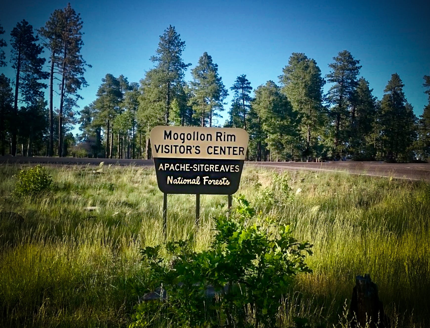
This is also the point where we unofficially leave Tonto National Forest and enter the expansive realm of the Sitgreaves National Forest, part of the larger Apache-Sitgreaves National Forests administrative unit.
This stretch of the Mogollon Rim here in Arizona is uniquely managed by a trio of National Forests: Coconino National Forest (Rim Ranger District), Tonto National Forest (Payson Ranger District), and Apache-Sitgreaves National Forests (Black Mesa Ranger District). It’s a little administrative patchwork, but together, they steward this high country corridor with all its trails, overlooks, campgrounds, and jaw-dropping views. It’s a reminder that this isn’t just a scenic route, it’s a vast, living system of wilderness, history, and caretaking.

Now, if you’re glancing at a map and scratching your head, you’re not alone. It can be confusing. Although it’s commonly labeled as Apache-Sitgreaves, we’re actually in the Sitgreaves portion here on the western side. The Apache side stretches much farther east, toward the New Mexico border. Together, they’re managed as one unified forest, but the terrain shifts subtly as you go. Although there is no real distinction other than the iconic national forest sign, each part does have its own distinct feel.
From here, the Rim’s forested corridor continues on toward Pinetop-Lakeside, our home for the next couple of nights. Nestled deep in the Apache-Sitgreaves National Forest, it’s the perfect basecamp to explore this green, elevated wonderland and confusing forest labels. Nevertheless, it’s wild to think that this green ribbon of high country stretches nearly 200 miles from Flagstaff to the edge of New Mexico. And here we are, just one small thread in that enormous tapestry. But what a beautiful one to be part of.
Crossing from Tonto into the Sitgreaves National Forests feels like entering a quieter, greener chapter of the Mogollon Rim. While Tonto carries that rugged, canyon-carved character, where desert meets pine, the Sitgreaves side of Apache-Sitgreaves feels entirely different. It offers a cooler, denser forest experience, more alpine than arid.
You're still traveling along the mighty Mogollon Rim here, just in a new stretch of its vast backbone. This part of the forest is defined by high-elevation lakes, thick stands of pine and fir, and the kind of quiet that feels almost alpine (I know, I already said that, but it does). Though the full Apache-Sitgreaves spans over 2 million acres stretching into eastern Arizona and even western New Mexico, this particular section hugging the Rim through Heber, Show Low, and Pinetop-Lakeside feels tucked into a softer wilderness. Less dramatic than Tonto’s cliffs, perhaps, but just as wild. And just as worthy of wonder. It was time to rest my brain and get back into my heart.
We left the Mogollon Rim Visitor Center with the sun on its slow climb toward zenith, the day already hinting at a cooler heat then Payson and golden brilliance to come. It seemed to beckon a sense of playfulness in the air. Forest Road 300, also known as Rim Road, is an 11- to 12-mile stretch that’s mostly paved and easy to navigate, even for RV’s under 40-feet. At either end, the journey branches into adjoining forest roads, inviting further exploration.
Some sections of the Rim feature sheer drop offs, where 2,000-foot limestone cliffs plunge into canyons below. The road beckoned with the promise of jaw-dropping views, remote lakes, and that rare feeling of being somewhere truly wild, yet still tethered to civilization, thanks to the scattered campgrounds and the Woods Canyon Lake Store and Marina. We decided this would be our destination however, that is a story for next week. I will cover the all the campgrounds along our adventure.
If you have not subscribed yet, why not? If you are subscribed, you will be alerted as soon as the next story drops and it will come effortlessly into your inbox or an alert on the app every Wednesday morning. So, hit that blue button right there and subscribe now. Thank you!
Once you do that and are feeling all kinds of fuzzy feels, how about tipping the Tipsmobile? With your generous tip I can continue to fuel your imagination.

If my adventures and stories are bringing a smile to your face, why not throw a little fuel in my tank to keep the wheels turning literally! Even creativity needs a top-up now and then! Your support keeps me inspired, and rolling down the road. Thanks for being part of the journey!
Need to catch up?
PT 40 Where the Pine Bark Smells Like Butterscotch: Only in Payson, Arizona
PT 39 Bulls’ Testicles and My Love-Hate Affair with Payson’s Wild West
Or, start from the beginning
Thank you for tuning in and reading this. I super appreciate you.
~Karen